Search icon CANCEL
Subscription
0
Cart icon
Your Cart (0 item)
Close icon
You have no products in your basket yet
Save more on your purchases! discount-offer-chevron-icon
Savings automatically calculated. No voucher code required.
Arrow left icon
All Products
Best Sellers
New Releases
Books
Videos
Audiobooks
Learning Hub
Newsletter Hub
Free Learning
Arrow right icon
timer SALE ENDS IN
0 Days
:
00 Hours
:
00 Minutes
:
00 Seconds
Arrow up icon
GO TO TOP
Spatial Analytics with ArcGIS

You're reading from   Spatial Analytics with ArcGIS Build powerful insights with spatial analytics

Arrow left icon
Product type Paperback
Published in Apr 2017
Publisher Packt
ISBN-13 9781787122581
Length 290 pages
Edition 1st Edition
Languages
Tools
Arrow right icon
Author (1):
Arrow left icon
Eric Pimpler Eric Pimpler
Author Profile Icon Eric Pimpler
Eric Pimpler
Arrow right icon
View More author details
Toc

Table of Contents (16) Chapters Close

Title Page
Credits
About the Author
About the Reviewer
www.PacktPub.com
Customer Feedback
1. Introduction to Spatial Statistics in ArcGIS and R FREE CHAPTER 2. Measuring Geographic Distributions with ArcGIS Tools 3. Analyzing Patterns with ArcGIS Tools 4. Mapping Clusters with ArcGIS Tools 5. Modeling Spatial Relationships with ArcGIS Tools 6. Working with the Utilities Toolset 7. Introduction to the R Programming Language 8. Creating Custom ArcGIS Tools with ArcGIS Bridge and R 9. Application of Spatial Statistics to Crime Analysis 10. Application of Spatial Statistics to Real Estate Analysis

The Analyzing Patterns toolset


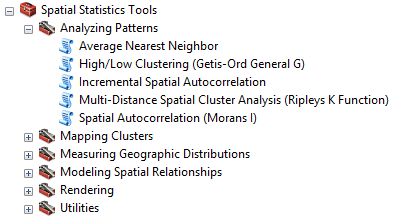
The Analyzing Patterns toolset, found in the Spatial Statistics Tools toolbox and shown in the following screenshot, contains a set of tools that perform pattern analysis against a dataset. Each of these tools returns statistical information about the entire dataset. The output of these tools is not a map, but rather statistical information that helps determine if a dataset is clustered, dispersed, or has a random pattern.

To help interpret the results of these tools, this section will provide information about the null hypothesis, p-values, z-scores, and standard deviations.

Understanding the null hypothesis

All the pattern analysis tools that we examine in this chapter work on the premise that our features or the values associated with those features are randomly distributed. This is known as Complete Spatial Randomness (CSR). This is the null hypothesis used with all the ArcGIS spatial statistics tools.

The pattern analysis tools return z-scores and p-values...

lock icon The rest of the chapter is locked
Register for a free Packt account to unlock a world of extra content!
A free Packt account unlocks extra newsletters, articles, discounted offers, and much more. Start advancing your knowledge today.
Unlock this book and the full library FREE for 7 days
Get unlimited access to 7000+ expert-authored eBooks and videos courses covering every tech area you can think of
Renews at $15.99/month. Cancel anytime
Visually different images