Search icon CANCEL
Subscription
0
Cart icon
Your Cart (0 item)
Close icon
You have no products in your basket yet
Save more on your purchases! discount-offer-chevron-icon
Savings automatically calculated. No voucher code required.
Arrow left icon
All Products
Best Sellers
New Releases
Books
Videos
Audiobooks
Learning Hub
Newsletter Hub
Free Learning
Arrow right icon
timer SALE ENDS IN
0 Days
:
00 Hours
:
00 Minutes
:
00 Seconds
Arrow up icon
GO TO TOP
Python Geospatial Analysis Cookbook

You're reading from   Python Geospatial Analysis Cookbook Over 60 recipes to work with topology, overlays, indoor routing, and web application analysis with Python

Arrow left icon
Product type Paperback
Published in Nov 2015
Publisher
ISBN-13 9781783555079
Length 310 pages
Edition 1st Edition
Languages
Arrow right icon
Author (1):
Arrow left icon
 Diener Diener
Author Profile Icon Diener
Diener
Arrow right icon
View More author details
Toc

Table of Contents (20) Chapters Close

Python Geospatial Analysis Cookbook
Credits
About the Author
About the Reviewers
www.PacktPub.com
Preface
1. Setting Up Your Geospatial Python Environment FREE CHAPTER 2. Working with Projections 3. Moving Spatial Data from One Format to Another 4. Working with PostGIS 5. Vector Analysis 6. Overlay Analysis 7. Raster Analysis 8. Network Routing Analysis 9. Topology Checking and Data Validation 10. Visualizing Your Analysis 11. Web Analysis with GeoDjango Other Geospatial Python Libraries
Mapping Icon Libraries
Index

Snapping a point to the nearest line


Building on our newly gained wisdom from the last recipe, we will now attack another common spatial problem. This super common spatial task is for all the GPS junkies who want their GPS coordinates to snap to an existing road. Imagine that you have some GPS tracks and you want to have these coordinates snap to your base road dataset. To accomplish such a task, we need to snap a point (GPS coordinates) to a line (roads).

The geos library is what Shapely is built on and can handle this problem with ease. We will combine the use of the shapely.interpolate and shapely.project functions to snap our point to the true nearest point on the line using linear referencing.

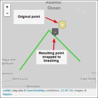
As you can see in the following diagram, our input point is located on the sun icon. The green line is what we want to snap our point to at the nearest location. The gray icon with a point on it is our result that represents the nearest point on the line from our original x position.

How to do it...

lock icon The rest of the chapter is locked
Register for a free Packt account to unlock a world of extra content!
A free Packt account unlocks extra newsletters, articles, discounted offers, and much more. Start advancing your knowledge today.
Unlock this book and the full library FREE for 7 days
Get unlimited access to 7000+ expert-authored eBooks and videos courses covering every tech area you can think of
Renews at $15.99/month. Cancel anytime
Visually different images