Search icon CANCEL
Subscription
0
Cart icon
Your Cart (0 item)
Close icon
You have no products in your basket yet
Save more on your purchases! discount-offer-chevron-icon
Savings automatically calculated. No voucher code required.
Arrow left icon
All Products
Best Sellers
New Releases
Books
Videos
Audiobooks
Learning Hub
Newsletter Hub
Free Learning
Arrow right icon
timer SALE ENDS IN
0 Days
:
00 Hours
:
00 Minutes
:
00 Seconds
Arrow up icon
GO TO TOP
Python Geospatial Analysis Cookbook

You're reading from   Python Geospatial Analysis Cookbook Over 60 recipes to work with topology, overlays, indoor routing, and web application analysis with Python

Arrow left icon
Product type Paperback
Published in Nov 2015
Publisher
ISBN-13 9781783555079
Length 310 pages
Edition 1st Edition
Languages
Arrow right icon
Author (1):
Arrow left icon
 Diener Diener
Author Profile Icon Diener
Diener
Arrow right icon
View More author details
Toc

Table of Contents (20) Chapters Close

Python Geospatial Analysis Cookbook
Credits
About the Author
About the Reviewers
www.PacktPub.com
Preface
1. Setting Up Your Geospatial Python Environment FREE CHAPTER 2. Working with Projections 3. Moving Spatial Data from One Format to Another 4. Working with PostGIS 5. Vector Analysis 6. Overlay Analysis 7. Raster Analysis 8. Network Routing Analysis 9. Topology Checking and Data Validation 10. Visualizing Your Analysis 11. Web Analysis with GeoDjango Other Geospatial Python Libraries
Mapping Icon Libraries
Index

Merging rasters to generate a color relief map


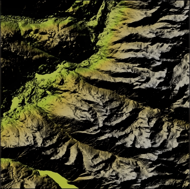
Generating a color relief raster is a one-liner with the gdaldem color-relief command line. If you want something that's a little more visually appealing, we will perform a combination of a slope, hillshade, and some color relief. Our end result is a single new raster representing a merge of layers to give a nice visual effect of elevation relief. The results are going to look similar to the following image:

Getting ready

For this exercise, you need to have the GDAL libraries installed that include the gdaldem command-line tool.

How to do it...

  1. Let's begin by extracting some key information out of our DEM using the gdalinfo\ch07\code>gdalinfo ../geodata/092j02_0200_demw.dem command-line tool as follows:

    Driver: USGSDEM/USGS Optional ASCII DEM (and CDED)
    Files: ../geodata/092j02_0200_demw.dem
           ../geodata/092j02_0200_demw.dem.aux.xml
    Size is 1201, 1201
    Coordinate System is:
    GEOGCS["NAD83",
        DATUM["North_American_Datum_1983",
            SPHEROID...
lock icon The rest of the chapter is locked
Register for a free Packt account to unlock a world of extra content!
A free Packt account unlocks extra newsletters, articles, discounted offers, and much more. Start advancing your knowledge today.
Unlock this book and the full library FREE for 7 days
Get unlimited access to 7000+ expert-authored eBooks and videos courses covering every tech area you can think of
Renews at $15.99/month. Cancel anytime
Visually different images