Search icon CANCEL
Subscription
0
Cart icon
Your Cart (0 item)
Close icon
You have no products in your basket yet
Save more on your purchases! discount-offer-chevron-icon
Savings automatically calculated. No voucher code required.
Arrow left icon
All Products
Best Sellers
New Releases
Books
Videos
Audiobooks
Learning Hub
Newsletter Hub
Free Learning
Arrow right icon
timer SALE ENDS IN
0 Days
:
00 Hours
:
00 Minutes
:
00 Seconds
Arrow up icon
GO TO TOP
Mastering PostGIS

You're reading from   Mastering PostGIS Modern ways to create, analyze, and implement spatial data

Arrow left icon
Product type Paperback
Published in May 2017
Publisher Packt
ISBN-13 9781784391645
Length 328 pages
Edition 1st Edition
Languages
Tools
Arrow right icon
Authors (4):
Arrow left icon
George Silva George Silva
Author Profile Icon George Silva
George Silva
 Mikiewicz Mikiewicz
Author Profile Icon Mikiewicz
Mikiewicz
Michal Mackiewicz Michal Mackiewicz
Author Profile Icon Michal Mackiewicz
Michal Mackiewicz
 Nycz Nycz
Author Profile Icon Nycz
Nycz
Arrow right icon
View More author details
Toc

Table of Contents (9) Chapters Close

1. Importing Spatial Data FREE CHAPTER 2. Spatial Data Analysis 3. Data Processing - Vector Ops 4. Data Processing - Raster Ops 5. Exporting Spatial Data 6. ETL Using Node.js 7. PostGIS – Creating Simple WebGIS Applications 8. PostGIS Topology 9. pgRouting

Slicing geometries


PostGIS is good at splitting geometries too. There are methods for splitting line and polygon geometries using a second geometry (blade), and for extracting sections of linear features based on distance.

Splitting a polygon by LineString

In our first example, we'll split a polygon (county boundary) using a line (river). We will use an ST_Split function for that.

This function accepts two arguments: a geometry to be split, which can be of the (Multi)Polygon or (Multi)LineString type, and a blade, which can be a LineString for polygons and LineStrings or a Point for lines:.

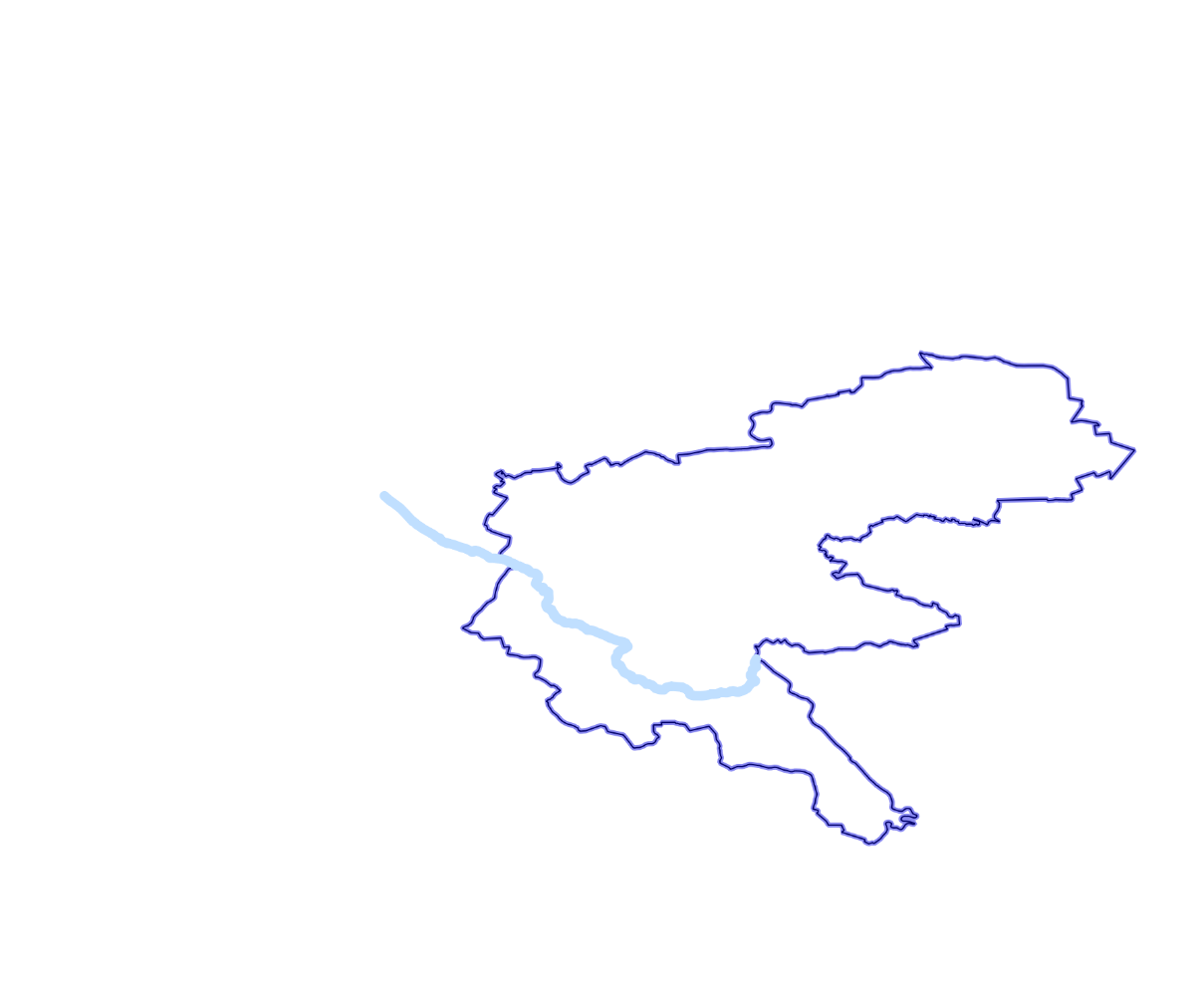
A polygon about to be split with a LineString used as a blade

SELECT ST_Split( 
 (SELECT wkb_geometry FROM multipolygons WHERE osm_id = '2417246'), 
 (SELECT wkb_geometry FROM lines WHERE osm_id = '224461074')) 

This yields a GeometryCollection, which isn't supported in most GIS software, including QGIS. To extract individual parts after splitting, and to visualize the result in QGIS, we'll need to use the...

lock icon The rest of the chapter is locked
Register for a free Packt account to unlock a world of extra content!
A free Packt account unlocks extra newsletters, articles, discounted offers, and much more. Start advancing your knowledge today.
Unlock this book and the full library FREE for 7 days
Get unlimited access to 7000+ expert-authored eBooks and videos courses covering every tech area you can think of
Renews at $15.99/month. Cancel anytime
Visually different images