Search icon CANCEL
Subscription
0
Cart icon
Your Cart (0 item)
Close icon
You have no products in your basket yet
Save more on your purchases! discount-offer-chevron-icon
Savings automatically calculated. No voucher code required.
Arrow left icon
All Products
Best Sellers
New Releases
Books
Videos
Audiobooks
Learning Hub
Newsletter Hub
Free Learning
Arrow right icon
timer SALE ENDS IN
0 Days
:
00 Hours
:
00 Minutes
:
00 Seconds
Arrow up icon
GO TO TOP
Mastering PostGIS

You're reading from   Mastering PostGIS Modern ways to create, analyze, and implement spatial data

Arrow left icon
Product type Paperback
Published in May 2017
Publisher Packt
ISBN-13 9781784391645
Length 328 pages
Edition 1st Edition
Languages
Tools
Arrow right icon
Authors (4):
Arrow left icon
George Silva George Silva
Author Profile Icon George Silva
George Silva
 Mikiewicz Mikiewicz
Author Profile Icon Mikiewicz
Mikiewicz
Michal Mackiewicz Michal Mackiewicz
Author Profile Icon Michal Mackiewicz
Michal Mackiewicz
 Nycz Nycz
Author Profile Icon Nycz
Nycz
Arrow right icon
View More author details
Toc

Table of Contents (9) Chapters Close

1. Importing Spatial Data FREE CHAPTER 2. Spatial Data Analysis 3. Data Processing - Vector Ops 4. Data Processing - Raster Ops 5. Exporting Spatial Data 6. ETL Using Node.js 7. PostGIS – Creating Simple WebGIS Applications 8. PostGIS Topology 9. pgRouting

The conceptual model


Before we start working with topology, we need to discuss the key concepts behind the PostGIS topological data model. PostGIS topology implementation is based on ISO standard 13249 - Information technology - Database languages - SQL multimedia and application packages - Part 3: Spatial. The standard name is often abbreviated as ISO SQL/MM. This standard defines two data models for topology: TopoGeometry and TopoNetwork; PostGIS implements only the former.

In this model, there are three kinds of elements/primitives used to compose geospatial features: nodes, edges, and faces.

Nodes are point features. They can exist on their own (isolated nodes) or serve as connection points for linear features (the edges). For example, this is a Czech-Polish-Slovak tripoint near Jaworzynka village, which contains a node and three edges:

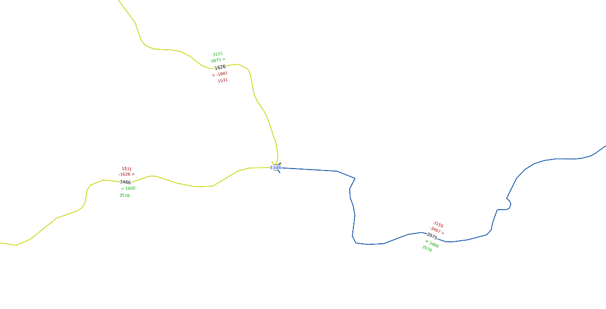
An example of topological data: a node and three edges

In topology, only one node can appear for a specified coordinate pair - if there are more nodes in...

lock icon The rest of the chapter is locked
Register for a free Packt account to unlock a world of extra content!
A free Packt account unlocks extra newsletters, articles, discounted offers, and much more. Start advancing your knowledge today.
Unlock this book and the full library FREE for 7 days
Get unlimited access to 7000+ expert-authored eBooks and videos courses covering every tech area you can think of
Renews at $15.99/month. Cancel anytime
Visually different images