Search icon CANCEL
Subscription
0
Cart icon
Your Cart (0 item)
Close icon
You have no products in your basket yet
Save more on your purchases! discount-offer-chevron-icon
Savings automatically calculated. No voucher code required.
Arrow left icon
All Products
Best Sellers
New Releases
Books
Videos
Audiobooks
Learning Hub
Newsletter Hub
Free Learning
Arrow right icon
timer SALE ENDS IN
0 Days
:
00 Hours
:
00 Minutes
:
00 Seconds
Arrow up icon
GO TO TOP
Python Geospatial Development

You're reading from   Python Geospatial Development Develop sophisticated mapping applications from scratch using Python 3 tools for geospatial development

Arrow left icon
Product type Paperback
Published in May 2016
Publisher
ISBN-13 9781785288937
Length 446 pages
Edition 3rd Edition
Languages
Tools
Arrow right icon
Author (1):
Arrow left icon
 Westra Westra
Author Profile Icon Westra
Westra
Arrow right icon
View More author details
Toc

Table of Contents (20) Chapters Close

Python Geospatial Development Third Edition
Credits
About the Author
About the Reviewer
www.PacktPub.com
Preface
1. Geospatial Development Using Python FREE CHAPTER 2. GIS 3. Python Libraries for Geospatial Development 4. Sources of Geospatial Data 5. Working with Geospatial Data in Python 6. Spatial Databases 7. Using Python and Mapnik to Generate Maps 8. Working with Spatial Data 9. Improving the DISTAL Application 10. Tools for Web-based Geospatial Development 11. Putting It All Together – a Complete Mapping System 12. ShapeEditor – Importing and Exporting Shapefiles 13. ShapeEditor – Selecting and Editing Features Index

Dealing with the anti-meridian line


If you explore the DISTAL application, you will soon discover a major usability problem with some of the countries. For example, if you click on United States in the Select Country page, you will be presented with the following map to click on:

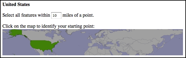
Accurately clicking on a desired point using this map would be almost impossible because it covers most of the earth's surface.

The problem is that Alaska crosses the anti-meridian line. The anti-meridian line is the line where the left and right sides of the world map join, that is, at ±180 degrees of longitude. Because of the way longitude values wrap around the globe, -180 degrees of longitude is the same as +180 degrees of longitude. The ±180 degree line is called the anti-meridian line and is the cause of many problems when dealing with geospatial data.

In the case of the USA, part of the Alaskan peninsula extends beyond 180 degrees west and continues across the Aleutian Islands to finish at Attu Island, which...

lock icon The rest of the chapter is locked
Register for a free Packt account to unlock a world of extra content!
A free Packt account unlocks extra newsletters, articles, discounted offers, and much more. Start advancing your knowledge today.
Unlock this book and the full library FREE for 7 days
Get unlimited access to 7000+ expert-authored eBooks and videos courses covering every tech area you can think of
Renews at $15.99/month. Cancel anytime
Visually different images