Search icon CANCEL
Subscription
0
Cart icon
Your Cart (0 item)
Close icon
You have no products in your basket yet
Save more on your purchases! discount-offer-chevron-icon
Savings automatically calculated. No voucher code required.
Arrow left icon
All Products
Best Sellers
New Releases
Books
Videos
Audiobooks
Learning Hub
Newsletter Hub
Free Learning
Arrow right icon
timer SALE ENDS IN
0 Days
:
00 Hours
:
00 Minutes
:
00 Seconds
Arrow up icon
GO TO TOP
Mastering  QGIS

You're reading from   Mastering QGIS Go beyond the basics and unleash the full power of QGIS with practical, step-by-step examples

Arrow left icon
Product type Paperback
Published in Sep 2016
Publisher Packt
ISBN-13 9781786460370
Length 486 pages
Edition 2nd Edition
Tools
Arrow right icon
Authors (5):
Arrow left icon
Kurt Menke, GISP Kurt Menke, GISP
Author Profile Icon Kurt Menke, GISP
Kurt Menke, GISP
 Corti Corti
Author Profile Icon Corti
Corti
 Smith Jr., GISP Smith Jr., GISP
Author Profile Icon Smith Jr., GISP
Smith Jr., GISP
 Pirelli Pirelli
Author Profile Icon Pirelli
Pirelli
 Van Hoesen, GISP Van Hoesen, GISP
Author Profile Icon Van Hoesen, GISP
Van Hoesen, GISP
+1 more Show less
Arrow right icon
View More author details
Toc

Table of Contents (19) Chapters Close

Mastering QGIS - Second Edition
Credits
Foreword
About the Authors
About the Reviewer
www.PacktPub.com
Preface
1. A Refreshing Look at QGIS FREE CHAPTER 2. Creating Spatial Databases 3. Styling Raster and Vector Data 4. Preparing Vector Data for Processing 5. Preparing Raster Data for Processing 6. Advanced Data Creation and Editing 7. Advanced Data Visualization 8. The Processing Toolbox 9. Automating Workflows with the Graphical Modeler 10. Creating QGIS Plugins with PyQGIS and Problem Solving 11. PyQGIS Scripting Index

Creating raster surfaces via interpolation


QGIS supports surface interpolation from vector points to a raster using the Interpolation plugin. The Interpolation tool supports Inverse Distance Weighted (IDW) and Triangular Interpolation (TIN). To enable the Interpolation plugin, click on Manage and Install Plugins under Plugins.

As an example of how to use the Interpolation tool, let's use the Pecos DEM Points.shp sample file to interpolate a surface using IDW:

  1. Add Pecos DEM Points.shp to the map canvas.

  2. Open the Interpolation plugin tool by navigating to Raster | Interpolation | Interpolation. The tool is shown in the following figure and uses the Pecos DEM Points.shp sample file as the input vector layer:

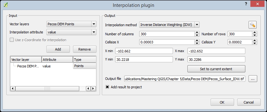
    The interface of the Interpolation tool is identical whether IDW or TIN is chosen as the Interpolation method. The only exceptions are the Interpolation method parameters, which can be set by clicking on the configure button (). For this example, we will only cover the IDW parameter (distance...

lock icon The rest of the chapter is locked
Register for a free Packt account to unlock a world of extra content!
A free Packt account unlocks extra newsletters, articles, discounted offers, and much more. Start advancing your knowledge today.
Unlock this book and the full library FREE for 7 days
Get unlimited access to 7000+ expert-authored eBooks and videos courses covering every tech area you can think of
Renews at £13.99/month. Cancel anytime
Visually different images