The reverse geocoding process
The reverse geocoding process is similar, but requires a different input and returns the results in a slightly different format.
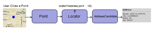
This process also uses a Locator task object that references a URL to a locator service. You create a Point geometry object, either as the result of the user clicking the map, or some other event generated by your application.
You then submit the Point object to the Locator task using the task's locationToAddress() method, together along with a value that represents distance. The distance property, supplied in meters, determines the radius in which the Locator will attempt to find an address. If the locator service finds an address within the specified radius, it returns a single AddressCandidate object to your callback function: