In this article by Matthew Sheehan, author of the book Developing Mobile Web ArcGIS Applications, GIS is a location-focused technology. Esri's ArcGIS platform provides a complete set of GIS capabilities to store, access, analyze, query, and visualize spatial data. The advent of cloud and mobile computing has increased the focus on location technology dramatically. By leveraging the GPS capabilities of most mobile devices, mobile users are very interested in finding out who and what is near them. Mobile maps and apps that have a location component are increasingly becoming more popular. ArcGIS provides a complete set of developer tools to satisfy these new location-centric demands.
(For more resources related to this topic, see here.)
Web ArcGIS development
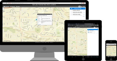
The following screenshot illustrates different screen sizes:
Web ArcGIS development is focused to provide users access to ArcGIS Server, ArcGIS Online, or Portal for ArcGIS services. This includes map visualization and a slew of geospatial services, which include providing users the ability to search, identify, buffer, measure, and much more.
Portal for ArcGIS provides the same experience as ArcGIS Online, but within an organization's infrastructure (on-premises or in the cloud). This is a particularly good solution where there are concerns around security.
The ArcGIS JavaScript API is the most popular among the web development tools provided by Esri. The API can be used both for mobile and desktop web application development.
Esri describes the ArcGIS API for JavaScript as "a lightweight way to embed maps and tasks in web applications." You can get these maps from ArcGIS Online, your own ArcGIS Server or others' servers." The API documents can be found at https://developers.arcgis.com/Javascript/jshelp/.
Mobile Web Development is different
Developers new to mobile web development need to take into consideration the many differences in mobile development as compared to traditional desktop web development. These differences include screen size, user interaction, design, functionality, and responsiveness. Let's discuss these differences in more depth.
Screen size and pixel density
There are large variations in the screen sizes of mobile devices. These can range from 3.5 inch for smartphones to more than 10.1 inches for tablets. Similarly, pixel density varies enormously between devices. These differences affect both the look and feel of your mobile ArcGIS app and user interaction. When building a mobile web application, the target device and pixel density needs careful consideration.
Interaction
Mobile ArcGIS app interaction is based on the finger rather than the mouse. That means tap, swipe and pinch. The following screenshot illustrates the Smartphone ArcGIS finger interactions:

Often, it is convenient to include some of the more traditional map interaction tools, such as zoom sliders, but most users will pan and zoom using finger gestures. Any onscreen elements such as buttons need to be large to allow for the lack of precision of a finger tap. Mobile ArcGIS app also provides new data input mechanisms. Data input relies on a screen-based, touch-driven keyboard. Usually, multiple keyboards are available, these are for character input, numeric input, and date input respectively. Voice input might also be another input mechanism.
Providing mobile users feedback is very important. If a button is tapped, it is good practice to give a visual cue of state change, such as changing the button color. For example, as shown in the following screenshots, a green-coloured button with the label, 'Online', changes to red and the label changes to 'Offline' after a user tap:

Design
A simple and intuitive design is key to the success of any mobile ArcGIS application. If your mobile application is hard to use or understand, you will soon lose users' attention and interest. Workflows should be easy. One screen should flow logically to the next. It should be obvious to the user how to return to the previous or home screen. The following screenshot describes small pop ups open to attributes screen:

ArcGIS mobile applications are usually map-focused . Tools often sit over the map or hide the map completely. Developers need to carefully consider the design of the application so that it is easy for users to return to the map.
GIS maps are made up of a basemap with the so called feature overlays. These overlays are map layers and represent geographic features, either through a point, line, or a polygon . Points may represent water valves, lines may be buried pipelines, while polygons may represent parks.
Mobile devices can change orientation from profile to landscape. On screen elements will appear different in each of these modes. Orientation again needs consideration during mobile application development.
The Bootstrap JavaScript framework helps automatically adjust onscreen elements based on orientation and a device's screen size.
Often, mobile ArcGIS applications have a multi-column layout. This commonly includes a layer list on the left side, a central map, and a set of tools on the right side. This works well on larger devices, but less well on smaller smartphones. Applications often need to be designed so that they can collapse into a single column when they are accessed from these smaller devices. The following screenshot illustrates the multiple versus single column layouts:

Mobile applications often need to be styled for a specific platform. Apple and Android have styling and design guidelines. Much can be done with stylesheets to ensure that an application has the look and feel of a specific platform.
Unlock access to the largest independent learning library in Tech for FREE!
Get unlimited access to 7500+ expert-authored eBooks and video courses covering every tech area you can think of.
Renews at AU $19.99/month. Cancel anytime
Functionality
Mobile ArcGIS applications often have different uses to their desktop-based cousins. Desktop web ArcGIS applications are often built with many tools and are commonly used for analysis. In contrast, mobile ArGIS applications provide a simpler, focused functionality. The mobile user base is also more varied and includes both GIS and non-GIS trained users. Maintenance staff, surveyors, attorneys, engineers, and consumers are increasingly interested in using mobile ArcGIS applications. Developers need to carefully consider both the target users and the functionality provided when they build any mobile ArcGIS web application. Mobile ArcGIS users do not want applications that provide a plethora of complex tools. Being simple and focused is the key.
Responsiveness
Users expect mobile applications to be fast and responsive. Think about how people use their mobile devices today. Gaming and social media are extremely popular. High performance is always expected . Extra effort and attention is needed during mobile web development to optimize performance. Sure, network issues are out of your hands, but much can be done to ensure that your mobile ArcGIS application is fast.
Mobile Browsers
There are an increasing number of mobile browsers that are now available. These include Safari, Chrome, Opera, Dolphin, and IE. Many are built using the WebKit rendering engine, which provides the most current browser capabilities. The following icons shows different mobile web browsers that are now available:

As with desktop web development, cross-browser testing is crucial as you cannot predict which browsers your users will use. Mobile functionality that works well in one browser may not work quite so well in a different browser. There are an increasing number of resources to help you with the challenges of testing such as modernizer.com, yepnopejs.com, and caniuse.com.
See the excellent article in Mashable on mobile testing tools at http://mashable.com/2014/02/26/browser-testing-tools/.
Web, native and hybrid mobile applications
The following screenshot illustrates three different types of mobile applications:

There are three main types of mobile applications: web, native, and hybrid. At one point of time, native was the preferred approach for mobile development . However, web technology is advancing at a rapid rate and in many situations, it could now be argued to be actually a better choice than native. Flexibility is a key benefits of mobile web as one code base runs across all devices and platforms. Another key advantage of a web approach is that a browser-based application, built with the ArcGIS JavaScript API, can be converted into an installable native-like application using technologies such as PhoneGap. These are called hybrid mobile apps.
Mobile frameworks, toolkits and libraries
JavaScript is one of the most popular languages in the world. It is an implementation of the ECMAScript language open standard . There are a plethora of available tools, built by the JavaScript community.
The ArcGIS JavacSript API is built on the Dojo framework. This is an open source JavaScript framework used for constructing dynamic web user interfaces. Dojo provides modules, widgets, and plugins, making it an very flexible development framework. Another extremely useful framework is jQuery Mobile. This is another excellent option for ArcGIS JavaScript developers.
Bootstrap is a popular framework for developing responsive mobile applications, as the following screenshot illustrates Bootstrap:

The framework provides automatic layout adaptation. This includes adapting to changes in device orientation and screen size. Using this framework means your ArcGIS web application will look good and be usable on all mobile devices: smartphones, phablet, and tablets.
PhoneGap/Cordova allows developers to convert web mobile applications to installable hybrid apps. This is another excellent open source framework. The following screenshot illustrates how to convert a web app to hybrid using Phonegap:

Hybrid apps built using PhoneGap can access mobile resources, such as GPS, camera, SD card, compass, and accelerometer, and be distributed through the various mobile app stores just like a native app.
Cordova is the open source framework that is managed by the Apache Foundation. PhoneGap is based on Cordova and PhoneGap is owned and managed by Adobe. For more information, go to
http://cordova.apache.org/.
The names are often used interchangeably, and in fact, the two are very similar. However, there is a legal and technical difference between them.
Summary
In this article, we introduced mobile web development by leveraging the ArcGIS JavaScript API. We discussed some of the key areas in which mobile web development is different than traditional desktop development. These areas include screen size, user interaction, design, functionality, and responsiveness. Some of the many advantages of mobile web ArcGIS development were also discussed, including flexibility wherein one application runs on all platforms and devices. Finally, we introduced hybrid apps and how a browser-based web application can be converted into an installable app using PhoneGap.
As location becomes ever more important to mobile users, so will the demand for web-based ArcGIS mobile applications. Therefore, those who understand the ArcGIS JavaScript API should have a bright future ahead.
Resources for Article:
Further resources on this subject:

 United States
 Great Britain
 India
India
 Germany
 France
 Canada
 Russia
 Spain
Spain
 Brazil
 Australia
 South Africa
 Thailand
 Ukraine
 Switzerland
 Slovakia
 Luxembourg
 Hungary
 Romania
 Denmark
 Ireland
 Estonia
 Belgium
 Italy
Italy
 Finland
 Cyprus
 Lithuania
 Latvia
 Malta
Malta
 Netherlands
 Portugal
 Slovenia
 Sweden
 Argentina
 Colombia
 Ecuador
 Indonesia
 Mexico
 New Zealand
 Norway
 South Korea
 Taiwan
 Turkey
 Czechia
 Austria
 Greece
 Isle of Man
 Bulgaria
 Japan
Japan
 Philippines
 Poland
 Singapore
 Egypt
Egypt
 Chile
Chile
 Malaysia